In two previous articles, we were able to examine the important advances in environmental protection in the Mediterranean, as well as the new priorities required to sustain our efforts to restore the good ecological status of our waters under jurisdiction. The challenge remains considerable. But, unlike in the 1970s, environmental protection in the Mediterranean will also benefit from new technologies that are reaching maturity. These open up new perspectives for the knowledge, monitoring and restoration of marine ecosystems.
First of all, it is about space technologies that already allow real-time monitoring of this sea, better management of maritime resources and valuable information in the event of an environmental crisis.
There is also the considerable development of drones and autonomous underwater vehicles that complement scientific observations by continuously collecting accurate data, but which will also bring unparalleled surveillance capabilities.
AI and big data are also transforming environmental data management by enabling the processing of large amounts of data to identify, classify and model marine ecosystems.
Finally, ecological restoration is taking on major importance. The purpose of this technique is to implement scientific and ecological techniques aimed at improving the quality and ecological functioning of a “natural” environment degraded by man.
This article is the latest in a trilogy resulting from the symposium held on 18 April 2025 and which was devoted to “New challenges for environmental protection in the Mediterranean” in the perspective of the Third United Nations Ocean Conference (UNOC3) held in Nice from 9 to 13 June 2025.
The first article[1] was devoted to the positive results of the actions undertaken since the 1970s to revisit a situation that led the Mediterranean to ecological disaster. The second article[2] identified the five new major environmental priorities identified in the Mediterranean so that France could meet the new environmental challenges that are now its own in its waters under jurisdiction.
This last contribution aims to identify these new technologies that open up new perspectives for the knowledge, monitoring and restoration of marine ecosystems. It should allow for an integrated vision in which space, robotics, artificial intelligence and ecological restoration approaches complement each other to offer innovative solutions that meet environmental, economic and societal challenges.=
The Mediterranean, a semi-closed sea under strong pressure, is becoming a privileged field for experimenting with these technologies, demonstrating that the link between science, innovation and public action is profoundly transforming the way marine life is managed.
Space, the future pillar of Mediterranean observation and surveillance?
The first major contribution to the protection of the Mediterranean is that of satellite remote sensing technologies, which already enable real-time monitoring of the sea, better management of maritime resources and valuable information in the event of an environmental crisis. The advancement of space observation technologies also enables the collection of environmental data with unprecedented accuracy. Satellites equipped with multiple sensors track critical parameters, such as primary productivity[3], facilitating a better understanding of ocean dynamics and the implementation of tools for the management and preservation of natural resources.
The development of space-based ocean observation has progressed quietly over a few decades, but is now a real revolution in the methods of monitoring the marine environment and monitoring our maritime spaces.
Thus, marine protected areas benefit from space technologies, enabling them to be monitored more effectively. This is the case, in particular, of the National Navy’s Trimaran 3 surveillance system, which combines satellite imagery collected from 300 optical observation or radar satellites, the detection of radio frequencies emitted by ships, ship identification data (AIS) and the operation of commercial databases (Lloyd’s list). These technologies allow for a considerable strengthening of the monitoring of marine protected areas, especially those in the offshore that are least accessible to conventional methods.
The fight against discharges of polluting products at sea has also benefited from new space technologies with the European marine pollution monitoring system CleanSeaNet. This device is based on satellite remote sensing. It was developed by the European Space Agency (ESA) and is managed under the Copernicus program. CleanSeaNet provides the Mediterranean Sea Prefect with real-time monitoring of marine pollution, mainly related to oil spills. Initially unreliable, CleanSeanet has become highly effective and can detect deliberate discharges of polluting products. Its deterrent aspect is no longer to be demonstrated.
The monitoring of the state of the marine environment by space sensors was initially focused on physical parameters such as temperature or surface topography. Now, spatial oceanography allows a fine monitoring of water color, plankton blooms, salinity, surface winds or air pollutants. These data are used by a multitude of actors, from public agencies to private operators, for applications ranging from port management to ecological planning. Currently, the satellite data used comes from sensors such as Sentinel (10 m resolution), Planet (3 to 5 m resolution) and Pleiades (images up to 30 cm in paid mode).
The proliferation of radar, optical or spectrometric sensors on board satellites, as well as advances in GNSS positioning systems[4] such as Galileo, have made it possible to gain in precision and frequency. At the same time, international cooperation – whether European, Sino-French or bilateral partnerships – enriches the volume and diversity of data available. The European Copernicus Marine Service program illustrates this ability to produce standardized and accessible data that is increasingly relevant and essential to coastal conservation policies.
Drones and robots: a new era for ocean exploration
Complementary to satellite observation, drones and autonomous underwater vehicles now make it possible to collect data on the surface or in immersion, with great precision and in areas sometimes inaccessible to conventional observation means. Originally developed for military or industrial uses, these machines are now used for civilian applications such as bathymetry, habitat monitoring, marine mammal detection or seabed inspection in offshore wind projects. From this point of view the company Exail is an excellent illustration of this duality. Originally developed for military purposes, it now operates extensively in environmental applications.
Drones will be an essential tool in the fight to preserve the marine environment. They offer a more efficient, cost-effective and less invasive alternative to traditional methods, while providing valuable data for public authorities, scientists and NGOs working to protect biodiversity and habitats.
These systems perform exceptionally well in terms of endurance and coverage of hard-to-reach areas. Their use allows a significant reduction in intervention times and optimization of data collection compared to traditional methods.
Robotic technologies make it possible, in particular, to drastically reduce operating times compared to traditional methods and to limit the environmental footprint (significant reduction in CO₂ emissions).
The sea, and especially the Mediterranean, is at the dawn of a considerable revolution with a planned massification of the use of drones. They will play an increasingly important role in monitoring marine ecosystems by collecting increasingly accurate data on water quality, understanding ecological changes, the status of marine mammal populations and fish and sensitive habitats, in areas where monitoring was often very difficult. Monitoring of posidonia beds or coralligenes could benefit fully from these new technologies. An excellent example in this area is the monitoring of the underwater volcano of Mayotte, since September 2021, by Explorer drones from Alseamar for the benefit of IFREMER.
Aerial drones with a low-cost sea-permanence capability will enable continuous monitoring of MPAs, including highly sensitive zones such as nature reserves and designated fishing areas. This offshore presence will probably be one of the best responses to the demand for increased monitoring expressed by environmental institutions.
Artificial intelligence and big data: the new frontier of knowledge
The rise of satellite sensors and images has led to an explosion in the volume of socio-environmental data. Artificial intelligence (AI), and in particular deep neural networks, now makes it possible to process this massive, heterogeneous and sometimes incomplete data. In marine ecology, AI is becoming a key tool for identifying, classifying, modeling, and predicting ecosystem dynamics.
Concrete applications illustrate this evolution. For example, an image-based rabbit fish detector[5] can map the expansion of this exotic species in the Mediterranean in real time from photos from participatory platforms. In industrial fishing, AI algorithms are now used to identify fishing vessels on satellite imagery, including those not using AIS tags (mandatory but often disabled). Current experiments in this field show that the majority of the industrial fishing fleet operating in the Mediterranean is still not subject to any form of official monitoring.
Another illustration is that AI can also be used to estimate the noise pollution generated by ships based on their speed, tonnage, and location data. Recent studies have shown alarming results in the Mediterranean, particularly in the Pelagos sanctuary for the protection of marine mammals, where noise levels can be very high.
In addition, the analysis of very high resolution images now makes it possible to detect fishing behavior, concentrations of plastic waste, or the presence of marine mammals. Artificial intelligence thus transforms a mass of pixels into information that can be directly used for management.
Beyond the image, the use of environmental DNA (eDNA) is revolutionizing the way marine biodiversity is understood. Sequencing of genetic traces from water can identify many species present at a given site, including those that are rare or discrete. Coupled with AI, this type of data can now overcome the limitations of conventional biodiversity inventories.
The joint exploitation of eDNA data, satellite images and acoustic or thermal sensors gives rise to new integrated approaches for monitoring. “Vision transformers” models can thus establish links between biodiversity and environmental pressures at different scales. These models move away from a localized view to integrate regional effects, such as sound refuges or habitat connectivity.
Modeling can also be used to develop management scenarios (“counterfactual”): What would happen if human usage in a bay were reduced? What if we forbade anchorages? What if we increase the density of boats? These simulation tools will become increasingly powerful decision-making tools for marine environmental protection authorities.
Among the new tools, let us not forget those that, by making knowledge sharing possible, strengthen environmental protection. The best illustration of this type of application is Donia, developed by Andromède Océanologie, whose vocation is to help sea users navigate and anchor their boats responsibly, without degrading sensitive marine ecosystems. By already providing more than 80,000 masters of ships and boaters with the detailed seabed mapping and maritime regulations in force, this application has been decisive in protecting posidonia seagrass beds and in improving their condition, which is currently under way.
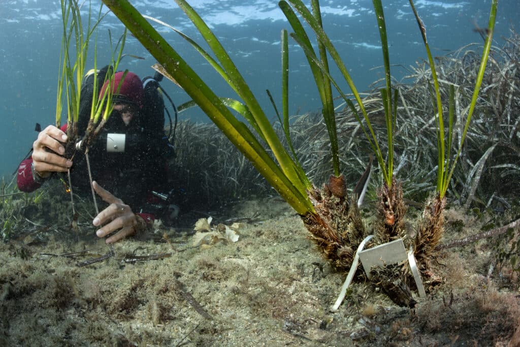
Restoration and rehabilitation: from technology to applied ecology
Finally, a final approach has become increasingly important in recent years with ecological restoration involving techniques to improve the quality and ecological functioning of a “natural” environment degraded by man.
There is a substantive debate between scientists on the subject. Should nature be allowed to regain its rights on its own in an area degraded by man or should it be given a “boost” to save time and allow a restart that in some cases would be impossible?
In reality, the choice between active restoration and letting nature take its course often depends on the specific context, which may be the type of habitat, the degree of artificialization, the resources available and the conservation objectives. In many cases, a combined approach, where active restoration is used to which may be the most effective approach, perhaps the most effective. Keeping in mind that it is also crucial to continue to reduce human pressures on degraded marine ecosystems to enable sustainable recovery (the case of posidonia seagrass beds).
The Mediterranean is currently a remarkable laboratory of ecological restoration techniques with, in particular, companies like Ecocean and Andromeda Oceanology. These two companies in the Montpellier region have developed ecological restoration technologies that are increasingly proving their worth. By investing in the protection and restoration of natural habitats of marine species, ecological restoration aims to preserve biodiversity and key ecosystem functions, such as nursery habitats. Thus, restoring degraded habitats, such as posidonia grass beds or coralligene, improves the overall health of marine ecosystems, which benefits all species that depend on them. If ecological restoration is successful, a virtuous chain is established with the improvement of water quality, the maintenance of habitat integrity, the increase of fishery resources and the increase of carbon sequestration.
In parallel with the monitoring tools, concrete initiatives in the Mediterranean have already been taken to restore degraded marine habitats. Rehabilitation of coralligenous substrates, transplantation of posidonic herbaria[6] or implantation of artificial nurseries in ports are underway and are already showing significant positive results.
These projects, sometimes experimental, are based on scientifically robust research projects, technical know-how (pumping, substrate stabilization, ecological anchorages) and a better understanding of biological cycles. Some initiatives, such as the rapid replanting of herbaria in Monaco or the restoration in Beaulieu-sur-Mer, demonstrate that ecological results can be significant, with high survival and recolonization rates if the conditions are right.
In artificial environments, devices such as Biohut can rehabilitate an ecological nursery function to impoverished and artificial environments forever. These substitute habitats harbor an active food chain, attract many species, and are effective means of sensitization while inducing no constraints for harbor operation. Ecological restoration, whether passive or assisted, involves restoring the conditions favorable to the return of biodiversity.
Conclusion
Sensors and digital technology are changing our relationship with the ocean. Through the intersection of spatial data, autonomous drones, AI and biotechnology, the capabilities for observation, diagnosis and action are rapidly transforming our ability to act on the marine environment. These innovations not only allow for a better understanding of ecosystems, but also for monitoring, restoring them and testing suitable management scenarios.
However, this technological revolution also poses challenges of ethics, accessibility, governance and prioritization. Data, no matter how accurate, cannot replace democratic debate or ambitious public policies. The future of the sea cannot be determined solely through screens: it will depend on our ability to use these tools to foster a renewed relationship between human societies and living marine life.
Rigorous, open, and unencumbered debate is therefore essential to fuel our collective intelligence. The WFTU is destined to play its part in this existential challenge for our oceans, the Mediterranean and our country.
[1] Feedback on measures to improve the environment in the Western Mediterranean (9 May 2025): https://fmes-france.org/retour-dexperience-sur-les-mesures-ayant-permis-une-amelioration-de-lenvironnement-en-mediterranee-occidentale/
[2] What new French priorities for the environment in the Mediterranean? (28 May 2025): https://fmes-france.org/quelles-nouvelles-priorites-francaises-pour-lenvironnement-en-mediterranee/
[3] Primary production in ecology is the production of plant organic matter (biomass), resulting from photosynthesis, by autotrophic organisms, called primary producers (definition of Actu-Environnement).
[4] The Global Navigation Satellite System is a set of satellites (constellation) that provides the geographical coordinates of ships on the oceans.
[5] Rabbit fish is a tropical species from the Red Sea that is currently present in the Eastern Mediterranean. This species by decimating the algae present on the bottom upsets certain ecological balances.
[6]The transplantation, since 2017, of posidonia seagrass beds in Monaco by Andromède Océanologie in Monaco as part of extension work at sea of the Principality shows that this technique is now mastered. In one year (2024 / 2025), these transplanted herbaria experienced 25% surface growth.